
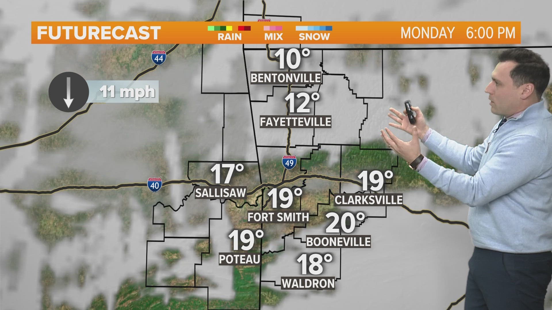
ARKANSAS, USA — More snow hit Arkansas on Monday as a fast-moving disturbance sweeps through. Widespread bands of snow showers will mainly hit south of Little Rock, while flurries and some isolated heavier bursts are possible around Northwest Arkansas and the River Valley.
Tap here to track the snow across the country as it heads toward Arkansas.
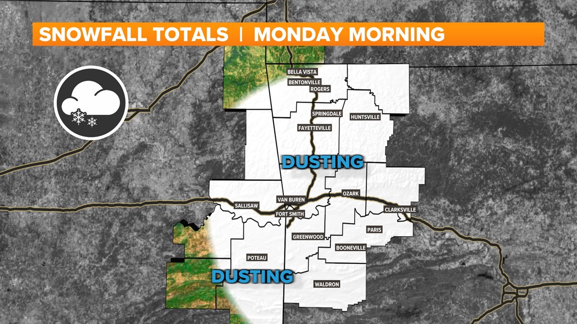
Additional snow accumulations will only range from a dusting up to a half inch. Most areas of NW Arkansas and the River Valley can expect to just see some morning flurries.

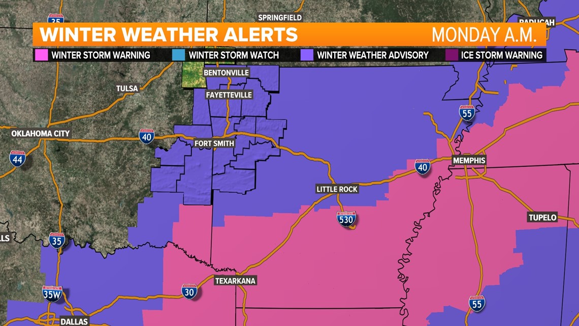
MONDAY'S ADVISORIES & WARNINGS
Areas of western Arkansas and eastern Oklahoma have been downgraded to a *WINTER WEATHER ADVISORY* for Monday mornings scattered snow showers. Travel is already tough with snow covered roads across the region.
Southern Arkansas is still highlighted under a *WINTER STORM WARNINGS* where heavier widespread snow and sleet will impact the morning commute. Wintery precipitation will taper off during the early afternoon hours, though frigid temperatures will keep the snow and ice around for a few more days.

Expect blowing snow at times as this system will produce very dry snow. Not great for a snowman. We also have a *WIND CHILL WATCH, due to the wind chills ranging from -20° to 0° through noon Tuesday.
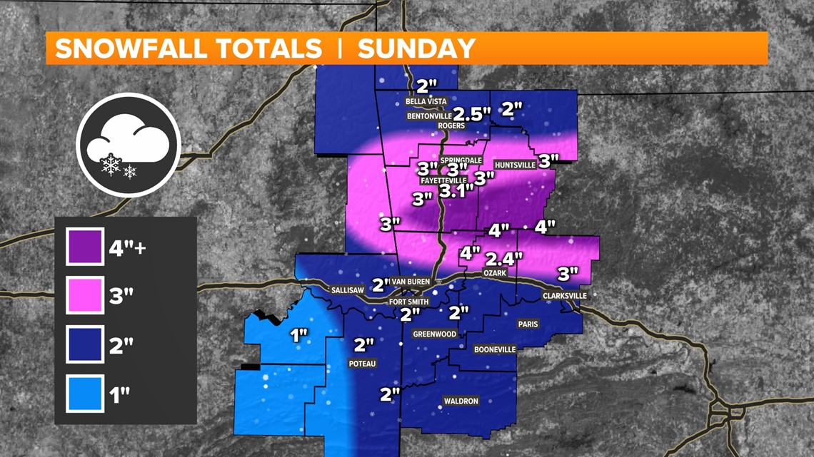
HOW MUCH SNOW DID WE GET SUNDAY?
This a very dry snow. That means per one inch of water in the atmosphere, we can squeeze out almost double the amount of snow than we typically get in a wet snow. These dry snowflakes will quickly add up. The frigid air over the state will keep the majority of the snow frozen, and around through Tuesday.

As sunshine and road crews start the process of melting this blanket of snow, well below freezing temperatures through Wednesday morning will set the stage for patchy black ice. Travel with caution until roads are completely clear and snow on the shoulders is removed.
What kind of impacts can you expect?
- The snow will not melt for a while. Some of this snow will last through Wednesday. That's 3 days of being snow covered. Roads will slowly clear with treatment.
- The snow is so dry and light that the wind will carry it more than normal, blowing it sideways at times. White out conditions will be possible during the heavier bursts and winds continue to gust over 20-30 MPH.
- Our snowpack will help reduce temperatures. We have a set forecast for lows across the state, but don't be surprised if the temperature falls even more than expected.
- Travel will be difficult during the snow. Make sure you have a safety kit and blankets in your car in case of an emergency. Once the snow ends, expect roads to remain slick for another day or so.
- Let your faucets drip starting Saturday night across the state.
Will my kids go back to school on Tuesday?
Obviously we don't make the ultimate decision. That being said, Tuesday morning wind chill values will still be anywhere between -5 and -15. Exposure is going to be a huge factor over the next few days. Real temperatures won't climb above the freezing point until we get to midday on Wednesday. Our regular newscasts Monday at 4, 5, and 6pm will air on 5+, Youtube, and Facebook due to NFL Football. So catch us on digital or the 10pm Newscast for school closings.
-5NEWS Weather Team