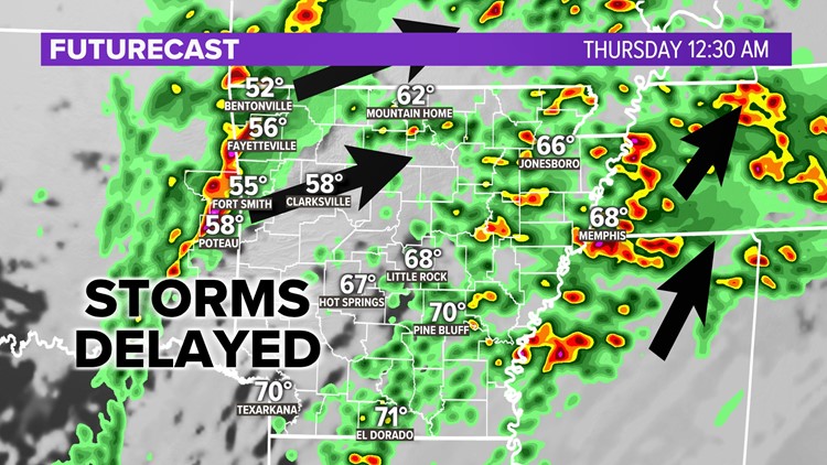
ARKANSAS, USA — UPDATE: Storms have been delayed by 1-2 hours. Expect strong storms to cross the AR-OK state line in Northwest Arkansas round 11 PM. They may cross the state line into the River Valley from 11P to midnight.
Humidity is slowly increasing from the south. This will help storms to continue into Arkansas, bringing wind and hail threats. Oklahoma has the higher tornado threat. But rotation is still possible in western Arkansas.
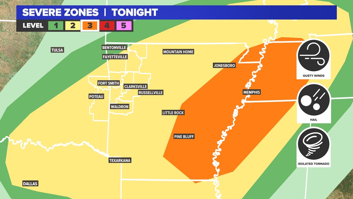
There are two areas to watch:
- Eastern Oklahoma & Western Arkansas
- Eastern Arkansas
Tap here for our weather radar to track incoming storms.
The zone to the west will get storms along the cold front as it moves in from central Oklahoma. These storms will fire with hail and tornado threats near Lake Eufaula. Over time these will press east, slowly weakening, but still bringing a moderate hail threat into Arkansas.
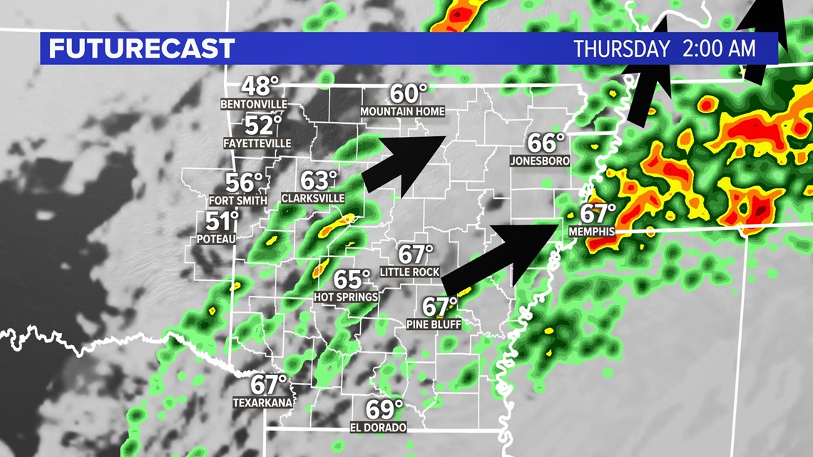
Many from Bentonville to Fort Smith and Greenwood will get some downpours and lightning.
The zone (orange, highest risk for this event) to the east from Little Rock to Memphis will get storms along the warm front surging north. These storms will have more sufficient humidity. Tornado risk is higher east of Little Rock and to the Mississippi River.
In between, parts of central Arkansas may just get rain and thunder.

Timing the storms
If these storms have enough moisture, which the eastern ones will, you can expect storms after sunset.
Cold front storms (west)
- 11 p.m. - midnight: Sallisaw, McAlester, Siloam Springs & Bentonville
- midnight. - 2 a.m.: Rogers, Springdale, Fayetteville, Fort Smith, Poteau, Greenwood, Van Buren, Clarksville, Booneville, Paris, Ozark, Alma, Waldron, Russellville, Texarkana
- 2 a.m. - 7 a.m.: Little Rock, Conway, Batesville, Searcy, Pine Bluff, El Dorado, Hot Springs, Benton
Warm front storms (east)
- Midnight - 9 a.m.: Memphis, Jonesboro
How will the storms evolve?
The western storms will cross the state line with pockets of hail and some rotation, mainly for the River Valley.
Heavy downpours and lightning are expected for Northwest Arkansas, with a slight hail threat.
In eastern Arkansas, waves of storms will push north, following the Mississippi River. These will have tornado and wind threats.
Into the early morning hours of Thursday, the western storms should weaken to mainly rain and thunder. in the east, storms will be larger with lots of heavy rain. Eventually they may run into one another, reducing the tornado threat over time.

Can this forecast bust?
Storms in the east should fire up no matter what. Severity levels will remain low to moderate. There is ample moisture for these storms, but upper level support may be a bit slow coming in.
Storms in the west are dependent on humidity. It is much drier to the west (see below). If humidity levels do not recover Wednesday afternoon, severe threats will greatly diminish. Or the storms will fire up, and then quickly weaken. If the humidity does recover, these storms will get nasty.
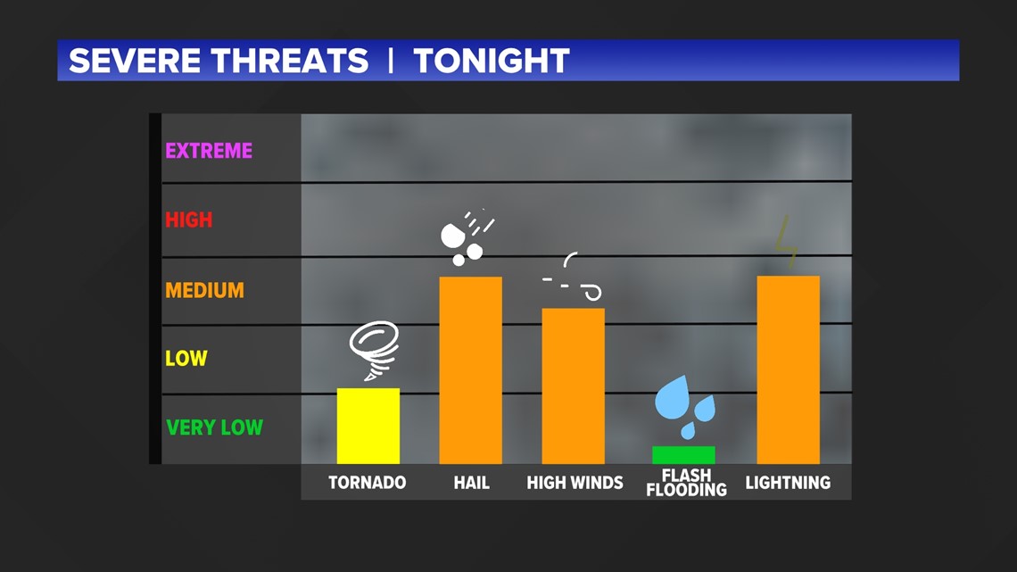
Overall threats
Wind and hail threats are the most concerning tonight. Especially in eastern Oklahoma with the colder air, hail may be easily able to form. Damaging winds are also possible.
Tornado threats are low, but not zero. Flash flooding should not be an issue in western Arkansas. Flooding may be a slightly higher threat in eastern Arkansas.