
ARKANSAS, USA — When a meteorologist is forecasting a storm during the winter months or even the colder months, the main question meteorologists focus on is: What type of precipitation will fall from that storm?
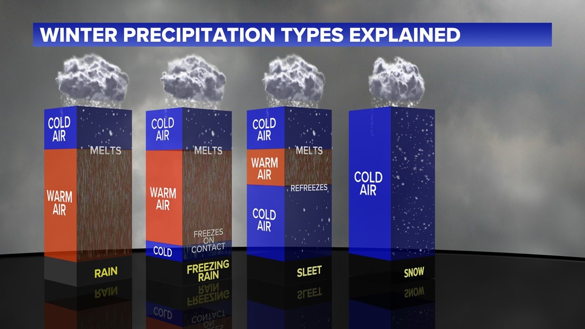
The type of precipitation is dependent on the vertical temperature profile of the atmosphere during that time above the ground. There are four different types we focus on: rain, freezing rain, sleet, and snow. For each to happen, there has to be certain atmospheric conditions to be met.
During the winter months, the precipitation that forms in the clouds above the ground is not raindrops, it's actually snowflakes, because it's so cold in the upper atmosphere.


For rain to happen, the snowflake starts to fall from the cloud and immediately hits warmer air that is above freezing, so that snowflake ends up completely melting and it continues to stay in warmer air throughout it's entire journey, therefore it hits the ground as rain.
For freezing rain and sleet to occur, things start to get a little more complicated.
To breakdown freezing rain first - what happens is that the snowflake in the cloud falls and immediately hits the warmer layer of air, so it melts. Then, above the ground, there is a very thin, shallow layer of air that is below freezing. What is now a raindrop after falling in the warm air, that raindrop meets that cold layer of air right above the ground. When it does meet that cold layer, it doesn't have time to completely freeze into an ice pellet due to the cold layer being so thin and shallow, so it reaches the ground and freezes on contact. When that happens, it creates ice on roadways, highways, and bridges and it becomes pretty messy when freezing rain occurs, because again, when it meets the ground where it's freezing and it turns into ice.
Now, let's talk about sleet. What happens with sleet is that when the snowflake falls from the cloud, it meets a very thin, shallow layer of warm air right beneath that cloud. When that snowflake falls through that warm air, it only partially melts into a rain drop, because that warm layer of air is so thin and shallow. Right underneath that warm layer is a thick layer of colder air, which continues all the way to the ground. That partially melted raindrop freezes into a ice pellet while it goes through that cold layer and ends up hitting the ground as an ice pellet, better known as sleet. When those ice pellets hit the ground, they end up bouncing off the ground.
Now the big one, snow. For snow to occur, the whole vertical temperature profile above the ground has to be a cold layer that is below freezing. So when a snowflake falls from the cloud, it continues its journey through that huge cold layer as a snowflake and touches the ground as snow.
Many times you can even get all four types to fall in one storm around NW Arkansas and the River Valley.

For Part 5 - Forecasting Wet Snow vs Dry Snow, Chief Meteorologist Matt Standridge shows us how wet snow forms compared to dry snow.
FULL WINTER WEATHER OUTLOOK FOR 2021-2022